
We’re one step closer to determining the location of the province’s first potential SMR facility.
We’ve narrowed our search for a site down to 2 near the City of Estevan — 1 on the Boundary Dam Reservoir within the RM of Estevan and the other on the Rafferty Reservoir in the RM of Cambria. We’ll proceed with detailed investigation through technical, environmental, social/cultural, and economic studies of the 2 sites, leading to final site selection in 2026.
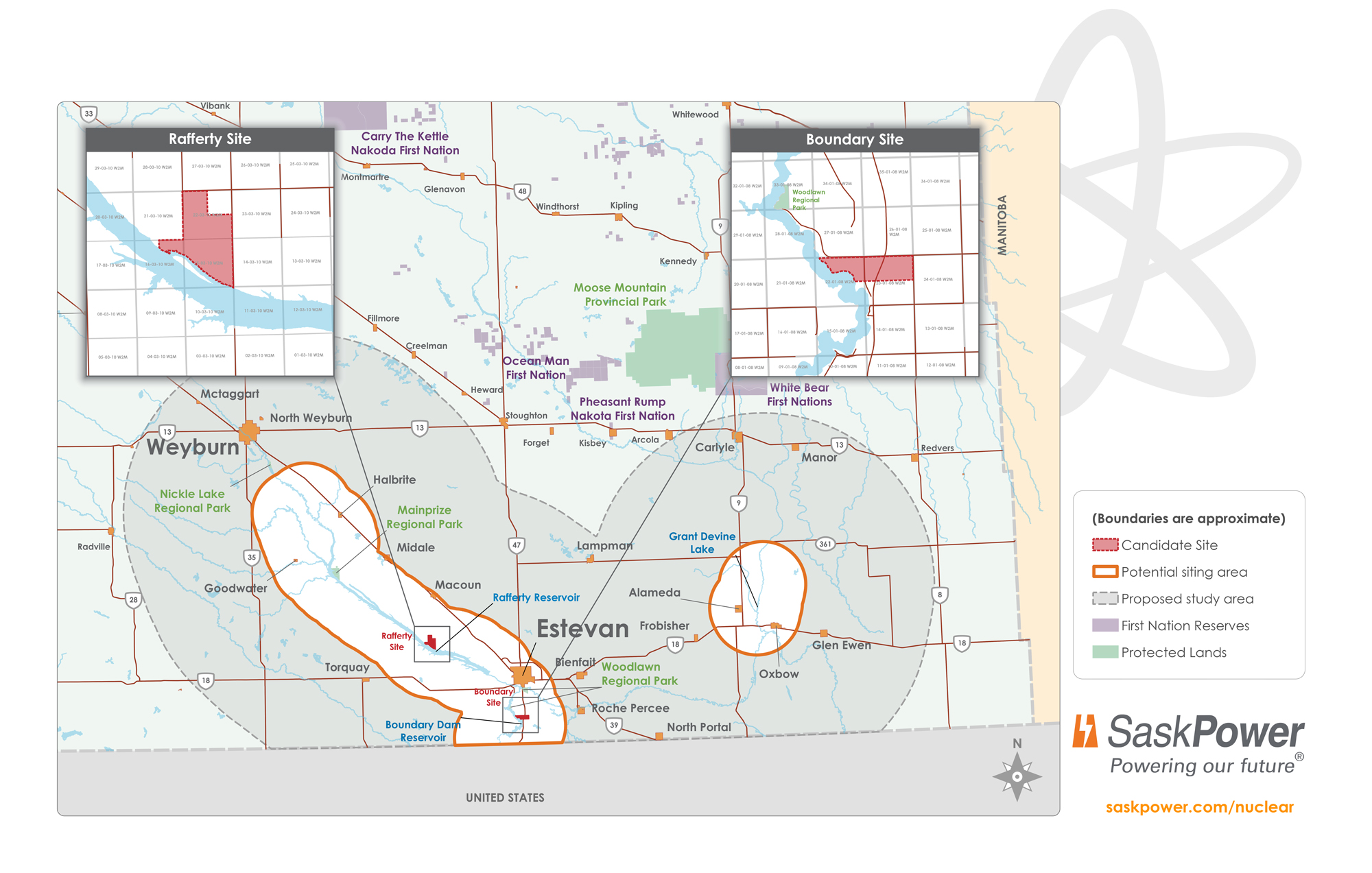
Selecting a site will allow us to proceed with many regulatory processes. This is site-specific and critical to moving the project forward as we work towards our final investment decision.
As we work towards final site selection, we recognize that input from Rightsholders, Indigenous and local leaders and the people that live, work and play near the potential sites is critical to help inform our work. We want to know what matters most to you as we compare the site options.
Learn more about our up coming events and share your priorities at saskpower.com/engage.
Site Selection Process
To start the siting process, we looked at regions across the province that could meet the requirements for the reactor technology we selected. We considered factors like a region’s proximity to:
- existing power infrastructure
- emergency services
- access to a workforce
Based on these factors, we selected 2 study regions to further evaluate – 1 near Estevan and 1 near Elbow.
Narrowing the Study Regions
From there we chose the 2 study regions, and we began to narrow in on specific areas within them that could work best to host a potential SMR facility.
Suitability Analysis
We identified areas of high and low suitability using over 50 criteria.
Land closer to water, transmission lines, highways, or larger communities is more suitable. Land near critical habitat, historic sites, or on unstable ground is less suitable.
Take a look at the Siting Indicator Workbooks below if you’re interested in learning more about look at the criteria and how it was used to help identify suitable land.
Water Intake Study
We identified the best stretches of shoreline to access water. Access to a body of water is a key consideration for siting an SMR which is needed for our chosen technology.
Regional Evaluation Process (REP)
We introduced a REP that helped improve our siting criteria and suitability analysis.
The process involved 4 committee workshops in each region. The committees had representatives from regional Indigenous groups, organizations, and stakeholders. It was a valuable way to engage with groups in each region on the siting process, and other aspects of the project.
All the REP materials are available to the public. You can read the REP Report, access documents and learn about the whole process at Regional Evaluation Process.
Tying it Together
To capture the combined results of the Suitability Analysis, Water Intake Study and REP, we created suitability maps and updated them along the way. The results of the Suitability Analysis are shaded in green and white:
- The darker the green, the more suitable the land.
- Areas in white are less suitable or not suitable at all.
- The black circles mark the findings from our Water Intake Study and identify areas where we could gain access to water.
- Elbow Suitability Map
- Estevan Suitability Map
